NitroX
|
| (.700 member) |
| 10/02/17 10:42 PM |

|
|
|
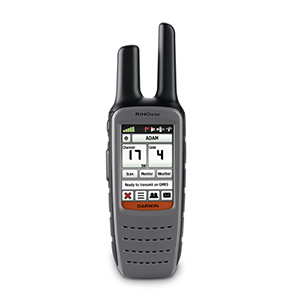
Rino® 650
$599.00 AUD
Rino 650 combines a 5 watt UHF radio with a 2.6" glove-friendly colour touchscreen GPS packed full of powerful features like a barometric altimeter, 3-axis compass and rechargeable Li-ion battery.
Pinpoint Your Position
With its high-sensitivity GPS receiver and HotFix, Rino 650 quickly finds your position and maintains it – even in heavy cover. Plus, a built-in barometric altimeter and 3-axis compass make it easy to get your bearings without the need to hold it level.
See Your Surroundings
Rino minisite
The device comes with a worldwide basemap with shaded relief, so you can navigate anywhere with ease. Adding more maps is easy with Garmin's wide array of detailed topographic, marine and road maps. With its microSD™ card slot, Rino 650 lets you load TOPO Australia & New Zealand maps and hit the trail or plug in BlueChart® g2 preloaded cards for a great day on the water. The device also supports BirdsEye™ Satellite Imagery (subscription required), that lets you download satellite images to your device and integrate them with your maps. In addition, Rino 650 is compatible with Custom Maps, free software that transforms paper and electronic maps into downloadable maps for your device.
Find Your Friends
Rino 650’s unique Position Reporting capability lets you send your exact location to other Rino users so they can see it on their map page. Plus, improved audio performance means it’s easy to communicate with any other conventional UHF radio in the area. It can be useful in an emergency, or just a handy way to keep tabs on your hunting party, hiking partner, family or friends.
Stay in Touch
With plenty of transmit power, Rino 650 also lets you send unit-to-unit text messages to other Rino users in your area – it's ideal for loud or windy conditions, or just when you don't want to disturb the wildlife. It also lets you share your waypoints, tracks, routes and geocaches wirelessly with other compatible Garmin handheld devices.
Physical & Performance
Physical dimensions 6.0 x 19.0 x 4.5 cm
Display size 3.6 x 5.5 cm; 6.6cm diag
Display resolution 160 x 240 pixels
Display type transflective, 65-K colour TFT
Weight 320 g with battery pack
Battery removable, rechargeable lithium-ion battery pack
Battery life 14 hours (up to 18 hours with optional AA battery pack)
Water rating IPX7
High-sensitivity receiver
Interface high-speed USB and NMEA 0183 compatible
Barometric altimeter
Electronic compass Yes (tilt-compensated 3-axis)
Transmit power 0 - 5 watts
Maps & Memory
Basemap
Ability to add maps
Built-in memory 1.7 GB
Accepts data cards microSD™ card (not included)
Waypoints/favorites/locations 2000
Routes 200
Track log 10,000 points, 200 saved tracks
Outdoor Features
Automatic routing (turn by turn routing on roads)
Geocaching-friendly
Hunt/fish calendar
Sun and moon information
Area calculation
Picture viewer
Two-way Radio Features
Frequency band UHF
Channels 80
Squelch codes 38 (CTCSS); 83 (DCS)
Range Up to 2 miles over FRS; up to 20 miles over GMRS (US); up to 13 km over GMRS (Canada)
VOX (voice activation)
Location reporting (send and receive GPS positions)
Vibration alert
https://buy.garmin.com/en-AU/AU/p/82798#specs